The National Hurricane Center on Wednesday forecast a system moving up the Texas coast could become the season’s first tropical storm.
Read more Public schools must excuse students for religious instruction, Florida AG says
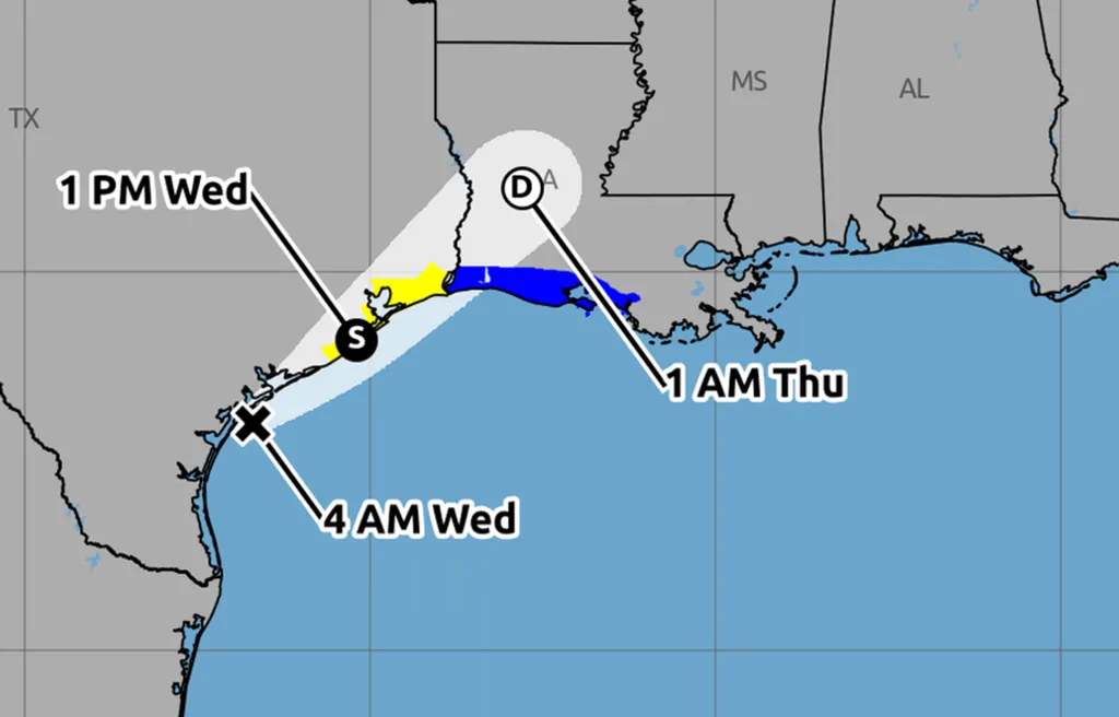
As of the NHC’s 11 a.m. advisory, the center of what is now named Potential Tropical Cyclone One was located about 35 miles southwest of Port O’Connor, Texas and 255 miles southwest of Lake Charles, Louisiana with maximum sustained winds of 30 mph and moving northeast at 6 mph.
“An increase in forward speed is expected today. On the forecast track, the low pressure area should move northeastward along the Texas coast today and then move inland over southwestern Louisiana by tonight,” forecasters said. “Some strengthening is forecast, and the disturbance could become a tropical storm today.”
6/17 4am CDT Key Messages for Potential Tropical Cyclone #One. The main hazard will be the potential for life-threatening flash flooding from heavy rainfall for portions of the southern and southeastern U.S. Visit https://t.co/tW4KeGdBFb for the latest updates. pic.twitter.com/8Ahd93dpmd
— National Hurricane Center (@NHC_Atlantic) June 17, 2026
If it becomes a named storm, it would be Tropical Storm Arthur, the first of the 2026 season for the Atlantic basin.
A tropical storm warning issued Tuesday remains in effect along the Louisiana coast from Sabine Pass, Texas, east to Morgan City while a tropical storm watch remains in effect from Sargent, Texas to Sabine Pass.
“Weakening is anticipated once the low moves inland, and it could dissipate by tonight or early Thursday,” forecasters said.
The NHC has dropped slightly its forecast chances that it will develop into the season’s first tropical depression or storm at 60% in the next two to seven days.
Whether it forms or not, the system is forecast to drop 5-10 inches of rain with some areas getting up to 20 inches through Thursday from the mid to upper Texas coast and much of Louisiana as well as portions of Mississippi and Alabama and the western portions of Georgia and the Florida Panhandle.
Read more Former Florida nursing school operator pleads guilty to selling diplomas
“This could generate dangerous to life-threatening flash flooding,” forecasters said
Tropical-storm conditions could begin early Wednesday within the watch area, and warning area by later Wednesday, while a storm surge threat of 2-4 feet is forecast from Port Bolivar, Texas to Morgan City, Louisiana. Swells from the system could cause life-threatening surf and rip current conditions along the northwestern Gulf Coast for the next couple of days.
The system could also produce tornadoes beginning Tuesday night threatening areas from the upper Texas coast across southern Louisiana, Mississippi, Alabama and the the Florida Panhandle, forecasters warn.
This is the first potential tropical system being tracked by the NHC in the Atlantic basin since the start of hurricane season.
The eastern Pacific has already been busy with three tropical storms, but so far the Atlantic basin has been quiet.
Hurricane season officially began June 1 and runs through Nov. 30. The height of hurricane season runs from mid-August into October.
The National Oceanic and Atmospheric Administration expects this season to be below normal with the official forecast released in late May calling for 8-14 named storms, of which 3-6 would become hurricanes. Of those, 1-3 would become major hurricanes reaching Category 3 status or above.
An average season has 14 named storms, seven hurricanes and three major hurricanes.
Read more Class of 2026: Seminole County’s valedictorians & salutatorians