
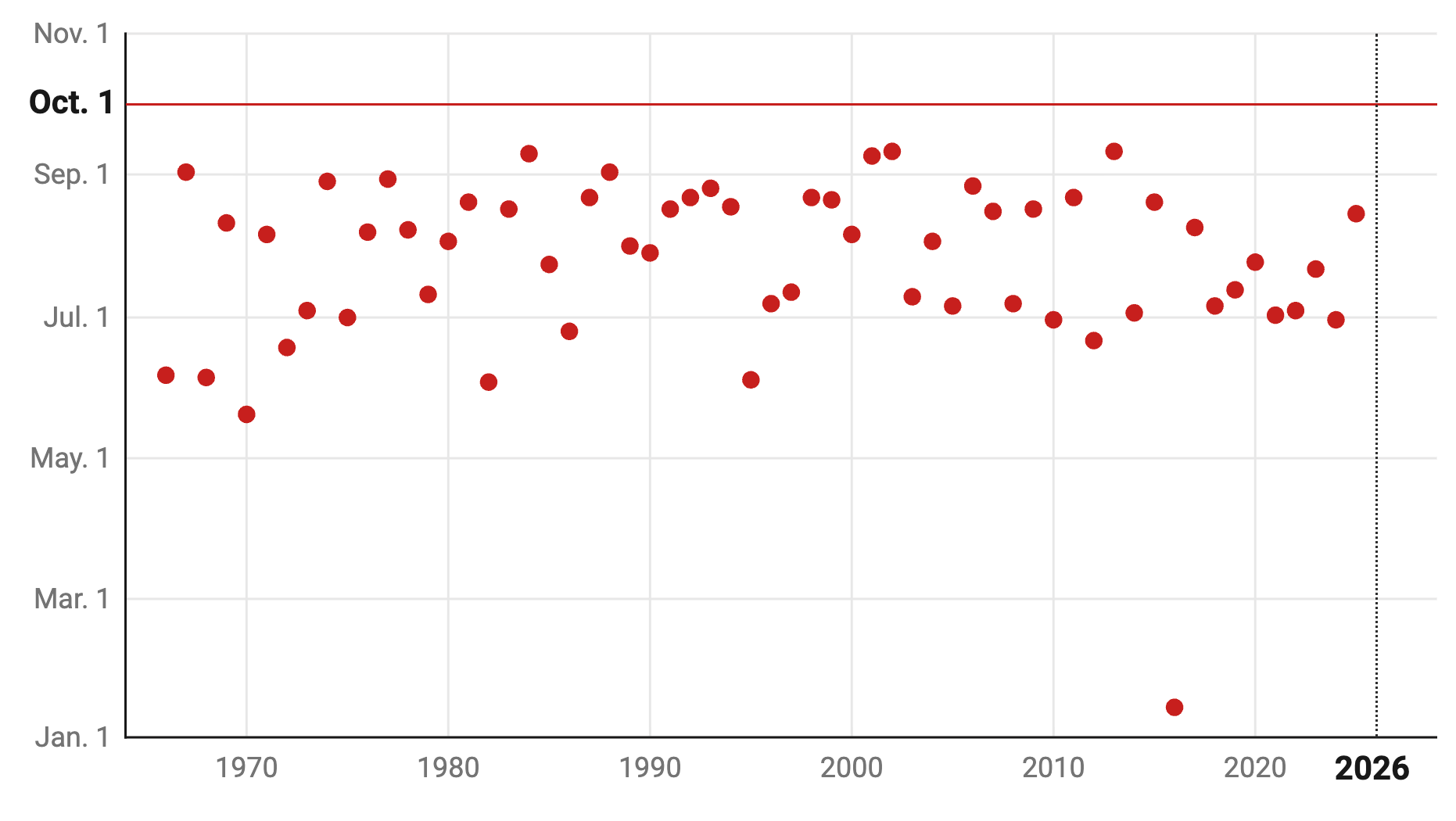
Not a single hurricane has formed in the Atlantic since this year’s season kicked off — a calm stretch through the end of September unmatched since satellite tracking began 60 years ago.
Read more Boom, boom, boom: 2 launches, 3 sonic booms and 1 Central Floridian to space
This marks a first for the era of satellite tracking — which began in 1966 — with no hurricanes forming in the Atlantic prior to Oct. 1.
Early to mid-September tends to be the peak of hurricane season.
“This year is unprecedented,” said Nick Novella, a meteorologist with the Weather Prediction Center.
Novella and other meteorologists say the low activity is influenced by the El Niño weather pattern, which is a warming of ocean surface temperatures in the central and eastern tropical Pacific Ocean.
“This El Niño event is quite strong and has the potential to be a historic one,” Novella said. “We’re seeing a lot of that warm water on the surface, but there’s also quite a bit of warm water underneath the surface.”
El Niño is spurring strong, widespread wind shear, which is a change in wind speed and direction. This wind shear is limiting the number of total storms and curbing the ability for storms to strengthen once they do form, Novella said.
Put another away: Sammy Hadi, a lead meteorologist with the National Weather Service in Miami, said the “top of these storms that are developing are being blown off.”
According to AccuWeather, the previous satellite-era record for the latest first hurricane was Sept. 11, set in both 2002 and 2013.
Since mid-June, the National Hurricane Center recorded eight tropical storms: Arthur, Bertha, Cristobal, Dolly, Edouard, Fay, Gonzalo and Hanna.
The Pacific, alternatively, has seen increased hurricane activity this year. According to Colorado State University, the Pacific has seen 20 named storms, 10 of which became hurricanes.
Read more Endorsement: Vote “no” on Amendments 1 and 2
Keeping an ‘eye out’ for storms
According to a recent report, AccuWeather now is predicting “the potential” for zero hurricanes in the Atlantic this season. “If this year’s Atlantic season has no hurricanes by Nov. 30, that will be only the third such season on record, preceded by 1914 and 1907,” AccuWeather said.
But hurricane season does not end until Nov. 30, which, according to Hadi and Novella, is plenty of time for a hurricane to form — and if not in the Atlantic, the Gulf of Mexico could produce one.
Hadi said South Florida historically has seen the greatest number of hurricane landfalls in October.
“We need to keep an eye out,” he said. “As far as physical likelihood, it’s very difficult to predict.”
Novella said sea-surface temperatures in the Gulf of Mexico are “very, very warm right now,” mainly because “it’s been untapped, so to speak, with any kind of tropical storm development for quite some time.”
“So if we do see a tropical storm form there, that could be quite favorable to actually push us into the hurricane territory,” he said. “Folks should always ensure to take the proper steps to prepare now that the hurricane season is still in full swing, even though we will start to kind of wind down here a little bit, the more we get later into October and into November.”
Beyond hurricane season, the El Niño pattern is forecast to “persist into the upcoming winter,” Hadi said, which could have other weather impacts.
“We might have a wetter and cooler winter with more threat of severe weather,” he said. “Wind shear is bad for tropical systems, but it’s very favorable for severe weather. … There’s a greater potential of tornadoes and strong wind gusts potentially during this upcoming fall until winter.”
Read more Tickets, food, merch: Magic introduce value options for games at Kia Center