The National Hurricane Center on Wednesday said Tropical Storm Arthur formed off the Texas coast making it the Atlantic season’s first named storm.
Read more Miss Manners: It was a nice dinner until my friend took their socks off
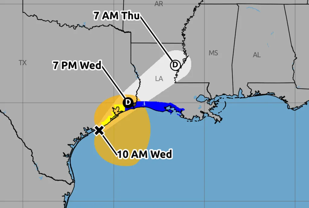
As of the NHC’s 11 a.m. advisory, the center of Arthur was located about 40 miles east-northeast of Port O’Connor, Texas and 190 miles west-southwest of Lake Charles, Louisiana with maximum sustained winds of 40 mph and moving northeast at 9 mph.
Tropical-storm-force winds extend out 175 miles from its center.
“An increase in forward speed is expected today. On the forecast track, the low pressure area should move northeastward along the Texas coast today and then move inland over southwestern Louisiana by tonight,” forecasters said. ”
The National Hurricane Center Director Dr. Michael Brennan will provide the LIVE update on Potential Tropical Cyclone One around 11:15 AM EDT today June 17, 2026. Please join us on Facebook Live and NHC YouTube Page at: https://t.co/rI6en9YUJXhttps://t.co/HwaVRhRCj3 pic.twitter.com/pOM9aeYHNg
— National Hurricane Center (@NWSNHC) June 17, 2026
A tropical storm warning issued Tuesday was expanded running from High Island, Texas east to Morgan City, Louisiana while a tropical storm watch remains in effect from Sargent, Texas to High Island.
“Little change in strength is expected before the center moves over land. Weakening is anticipated once the low moves inland, and it could dissipate by tonight or early Thursday,” forecasters said.
Tropical Storm Arthur tracking map: Updated path and forecast
The system is forecast to drop 5-10 inches of rain with some areas getting up to 20 inches through Thursday from the mid to upper Texas coast and much of Louisiana as well as portions of Mississippi and Alabama and the western portions of Georgia and the Florida Panhandle.
“This could generate dangerous to life-threatening flash flooding,” forecasters said
Read more More afternoon storms and hot weather as temps climb to nearly 100 degrees
Tropical-storm conditions could begin early Wednesday within the watch area, and warning area by later Wednesday, while a storm surge threat of 2-4 feet is forecast from Port Bolivar, Texas to Morgan City, Louisiana. Swells from the system could cause life-threatening surf and rip current conditions along the northwestern Gulf Coast for the next couple of days.
The system could also produce tornadoes beginning Tuesday night threatening areas from the upper Texas coast across southern Louisiana, Mississippi, Alabama and the the Florida Panhandle, forecasters warn.
This was the first potential tropical system being tracked by the NHC in the Atlantic basin since the start of hurricane season.
The eastern Pacific has already been busy with three tropical storms, but so far the Atlantic basin has been quiet.
Hurricane season officially began June 1 and runs through Nov. 30. The height of hurricane season runs from mid-August into October.
The National Oceanic and Atmospheric Administration expects this season to be below normal with the official forecast released in late May calling for 8-14 named storms, of which 3-6 would become hurricanes. Of those, 1-3 would become major hurricanes reaching Category 3 status or above.
An average season has 14 named storms, seven hurricanes and three major hurricanes.
Read more Asking Eric: The grandma was insulted, but I get why her gifts went unopened