The National Hurricane Center on Monday gave just a small chance a system in the Atlantic off the southeastern U.S. coast could develop into the season’s next tropical depression or storm.
Read more Florida’s gas prices swing back up 16 cents since last week
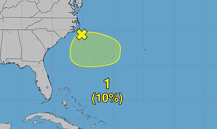
As of the NHC’s 8 a.m. tropical outlook, disorganized showers and thunderstorms off the southeast coast had developed in association with an area of low pressure along a frontal boundary.
“Environmental conditions only appear marginally favorable for some tropical development over the next day or two as the system drifts southward and then westward before conditions become even less favorable later this week,” forecasters said.
The NHC, which began tracking the potential system on Saturday, gives the system only a 10% chance to develop in the next two to seven days.
Sunday 6/28 8 pm EDT: NHC continues to monitor a low (10%) chance of tropical cyclone formation off of the southeastern U.S. coast during the next couple of days. Visit https://t.co/tW4KeGdBFb for the latest updates. pic.twitter.com/LEq95LO758
— National Hurricane Center (@NHC_Atlantic) June 29, 2026
If it develops, it could become a tropical depression or if powerful enough, be the second named storm of the season following the short-lived Tropical Storm Arthur that developed in the Gulf and brought floods to Texas and Louisiana earlier this month.
The next name on the hurricane season list is Bertha.
6/29/26 | Good morning east central Florida!
🥵 Hot and muggy today with a Heat Advisory across the north between 12 PM and 7 PM
⛈️ Showers and storms favored across the interior this afternoon
🏖️ Moderate rip risk at the beachesRead more DeSantis signs Florida budget, vetoes $800 million from lawmakers’ plan
Have a great Monday! pic.twitter.com/iWgr8gZbUf
— NWS Melbourne (@NWSMelbourne) June 29, 2026
For now, the National Weather Service in Melbourne said no matter whether it develops or not, moisture will build up this week in Florida ahead of the front raising the chances for storms to affect the region.
Those chances remain high through at least midweek.
“Primary storm impacts remain frequent lightning strikes, locally gusty winds of 35-50 mph, and torrential downpours,” forecasters said on Monday. “Due to the slow/erratic movement of cells, minor/nuisance flooding will remain one of the biggest storm concerns. Quick 2-3″ amounts may occur with a few storms late today and will be handled with Flood Advisories as necessary. Convection will diminish into mid-late evening, with skies thinning overnight.”
Hurricane season officially began June 1 and runs through Nov. 30. The height of hurricane season runs from mid-August into October.
The National Oceanic and Atmospheric Administration expects this season to be below normal with the official forecast released in late May calling for 8-14 named storms, of which 3-6 would become hurricanes. Of those, 1-3 would become major hurricanes reaching Category 3 status or above.
An average season has 14 named storms, seven hurricanes and three major hurricanes.
Read more As Florida sun heats up, will new sunscreen ingredients protect us?